

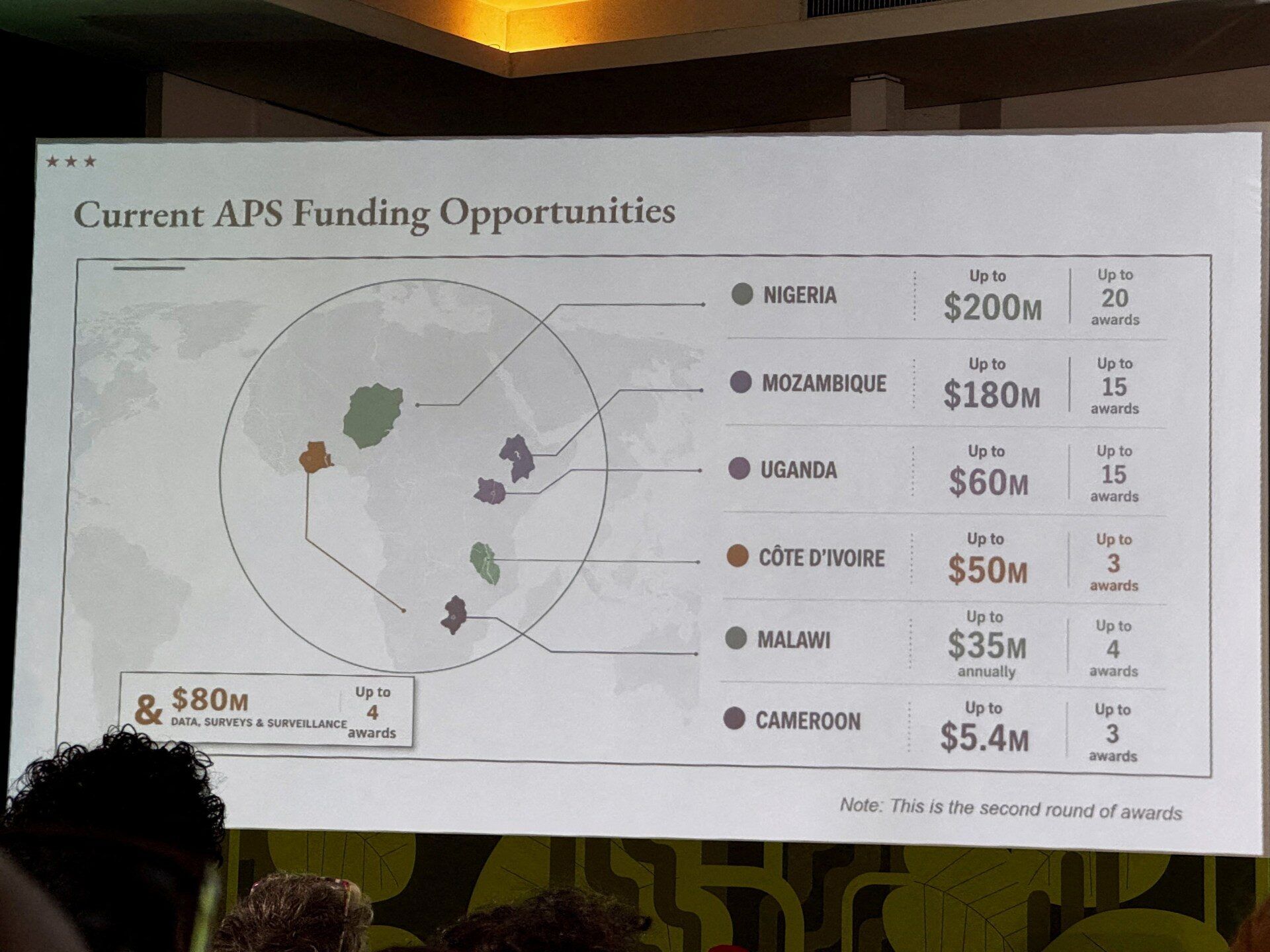
During a high-profile global health conference in Rio de Janeiro, the United States State Department inadvertently embarrassed itself—and its African partners—by presenting a grossly inaccurate map of the continent. The error, which misplaced multiple nations and distorted borders, sparked widespread online criticism before the department finally issued a formal apology for the “unfortunate mistake.”
The Map That Sparked Global Ridicule
At the AIDS 2026 conference, a presentation by the U.S. government featured a map of Africa that bore little resemblance to reality. Attendees, including diplomats, researchers, and activists, captured the screen in videos and photographs, which quickly circulated online. The map’s inaccuracies were immediate and glaring:
- Nigeria, Africa’s most populous nation, was incorrectly positioned in the Sahara Desert, far north of its actual location.
- Mozambique, a coastal country in southeastern Africa, was placed in the Horn of Africa, near Somalia and Ethiopia.
- Ivory Coast (Côte d’Ivoire), a West African nation, was depicted on the opposite side of the continent, near the Atlantic Ocean.
- Country boundaries were rendered as indistinct blobs, making it nearly impossible to distinguish one nation from another.
The map’s distortions were so severe that even basic geographical knowledge made the errors painfully obvious. The presentation was part of a discussion on U.S. health agreements with African nations, following the Trump administration’s controversial reduction of foreign aid, particularly in HIV/AIDS programs.
A Presentation by a Top U.S. Health Envoy
The mislabeled map appeared during a talk by Jeff Graham, the U.S. Global AIDS Coordinator and head of the President’s Emergency Plan for AIDS Relief (PEPFAR). Graham, a career diplomat with experience in Ghana and Ethiopia, was leading a discussion on the U.S. government’s renewed commitment to global health initiatives after a period of funding uncertainty.
PEPFAR, launched under President George W. Bush in 2003, had previously supported up to 20 million people worldwide—particularly in Africa—with antiretroviral therapies (ART) and HIV prevention programs. However, under the Trump administration, funding was temporarily suspended in 2020 pending a review, leading to disruptions in critical health services.
While PEPFAR’s core operations have since resumed, the U.S. has reduced HIV prevention and surveillance efforts in some regions. Notably, Washington has also planned to phase out PEPFAR’s presence in South Africa, despite the country bearing the world’s largest HIV burden, with over 7.5 million people living with the virus.
Was the Map Generated by AI?
Investigative reports, including those from Reuters, examined the presentation slides and discovered a watermark suggesting the map was likely created using AI-assisted design tools. OpenAI, the company behind the technology, confirmed it was investigating the incident to determine whether its tools were misused.
The State Department later admitted that the map was quickly assembled by a team member in the hours leading up to the conference, leading to the errors. In a formal statement, the department acknowledged:
“We take full responsibility for the confusion and misrepresentation it caused for attendees, including our African partners. While the discussions were substantive and constructive, we regret the unintended distraction this error created.”
Despite the blunder, the department reaffirmed its commitment to fighting HIV/AIDS and maintaining partnerships with African nations.
Broader Implications of the Geographical Error
Beyond the immediate embarrassment, the incident raises questions about preparation, oversight, and the role of technology in official communications. The use of AI-generated visuals—while efficient—can introduce risks if not properly vetted, particularly in diplomatic and humanitarian contexts where accuracy is paramount.
For African nations, the error underscored long-standing frustrations over Western perceptions of the continent, often reduced to stereotypes or oversimplified narratives. The mislabeled map, though unintentional, reinforced concerns about colonial-era cartographic biases that continue to influence global understanding of Africa.
A Lesson in Diplomacy and Precision
The U.S. State Department’s apology, while belated, reflects an acknowledgment of the seriousness of the mistake. However, the incident serves as a reminder of the high stakes in international health diplomacy, where misinformation—even unintentional—can undermine trust and credibility.
As global health conferences continue to shape policy and funding decisions, ensuring geographical accuracy, cultural sensitivity, and meticulous preparation remains essential. The AIDS 2026 conference, while marred by this blunder, ultimately underscored the critical importance of sustained efforts in combating HIV/AIDS—a fight that demands precision, partnership, and unwavering commitment.
